
Speed
From site to decision material in under 15 minutes.
Arcili combines map layers, registers, planning data and AI analysis in one workflow — so the team spends time on evaluation, not data collection.
Arcili combines maps, planning data, valuation and 3D project design in one platform. Project briefs that normally require three weeks and four consultants are delivered in hours.
Executive problem
Property development requires capital, timing and documentation. When data is spread across maps, registers, spreadsheets, consultant input and PDFs, screening slows down and risk becomes harder to compare.
Consequence
Teams spend time gathering data instead of assessing project quality, risks and commercial potential.
Constraints & rules
Drawings & calculations
Final deliverables — fragmented output
Building permit
Frame, drawings, calculations
Proposal & financials
Budget · build cost · IRR
Market analysis
Sales price · comparables
Local insight
Demographics · transit · schools
Strategic value
Arcili reduces manual preparation and consolidates the decision basis, so management can prioritise which projects move forward — earlier.
Speed
Arcili combines map layers, registers, planning data and AI analysis in one workflow — so the team spends time on evaluation, not data collection.
Consistency
Structured templates and automated extracts ensure every project is documented identically — regardless of who is at the keyboard.
Decision power
Management sees standardised decision material with embedded data source and audit log — not a PowerPoint without context.
Platform proof
The platform is built to preserve context through the entire development workflow: from the first screening to the report shared with management and advisors.
Strandvejen 142
Live fra Datafordeleren
42,3 mio. kr.
↑ 8,2% sidste år
78/100
Stærk udviklingscase
24 boliger · 6 etager
Auto-genereret
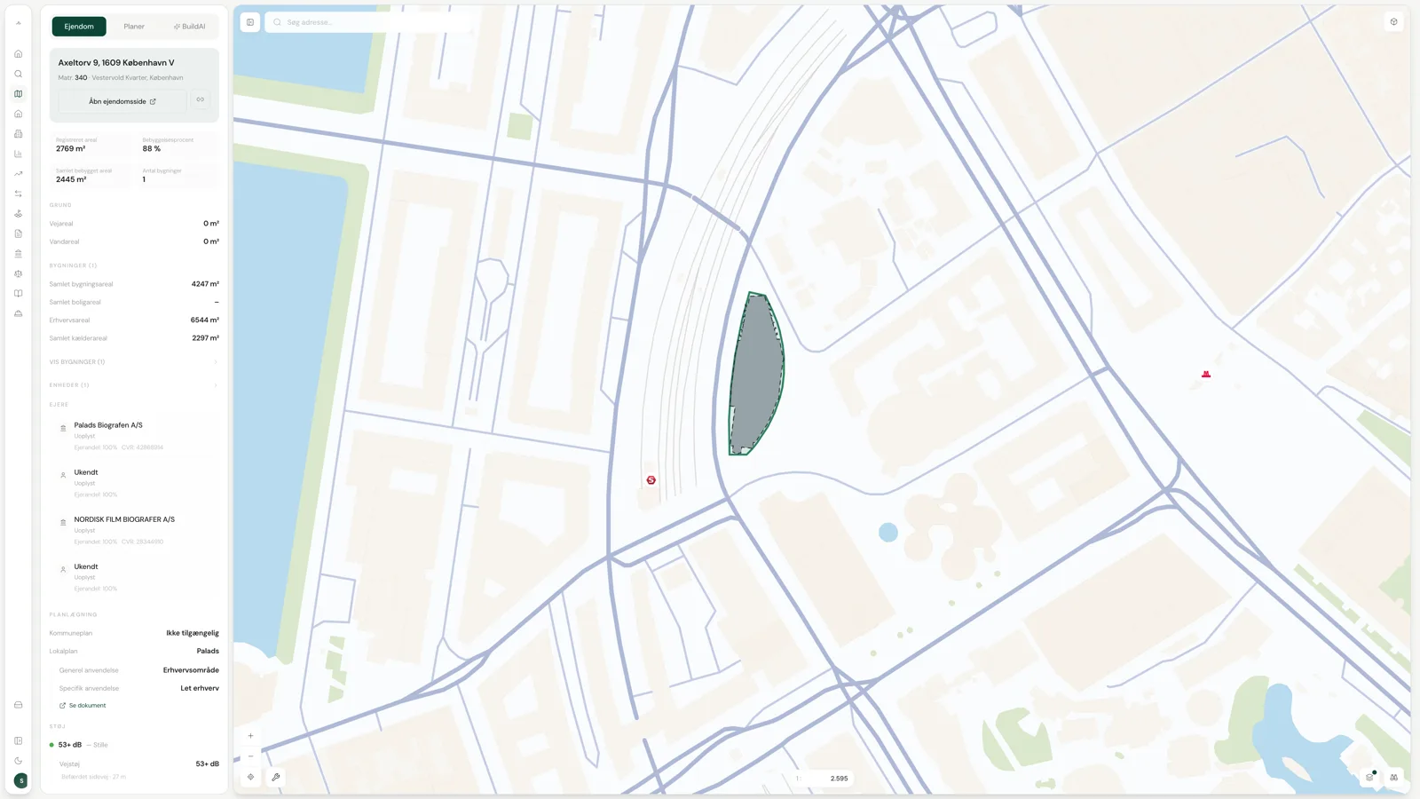
Search by address, cadastral ID or company. Arcili consolidates map layers, BBR, ownership data and planning information on one screen.
Project review helps the team see building rights, restrictions, coastal proximity, environmental conditions and other factors affecting the process.
Continue with site plans, AI price estimates, specialist assistants and early project proposals while preserving the context.
Export a consistent decision basis for management, investors, advisors or the municipality without losing the data source.
Modules
Arcili is not a collection of separate tools. The whole platform shares the same data foundation — from the first plot lookup on the map to the finished project brief ready for the municipality.
The core module
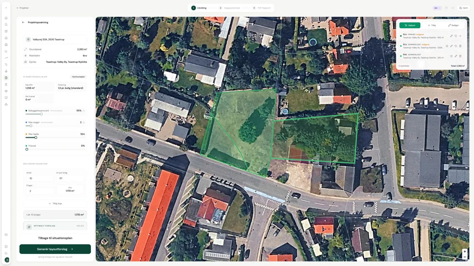
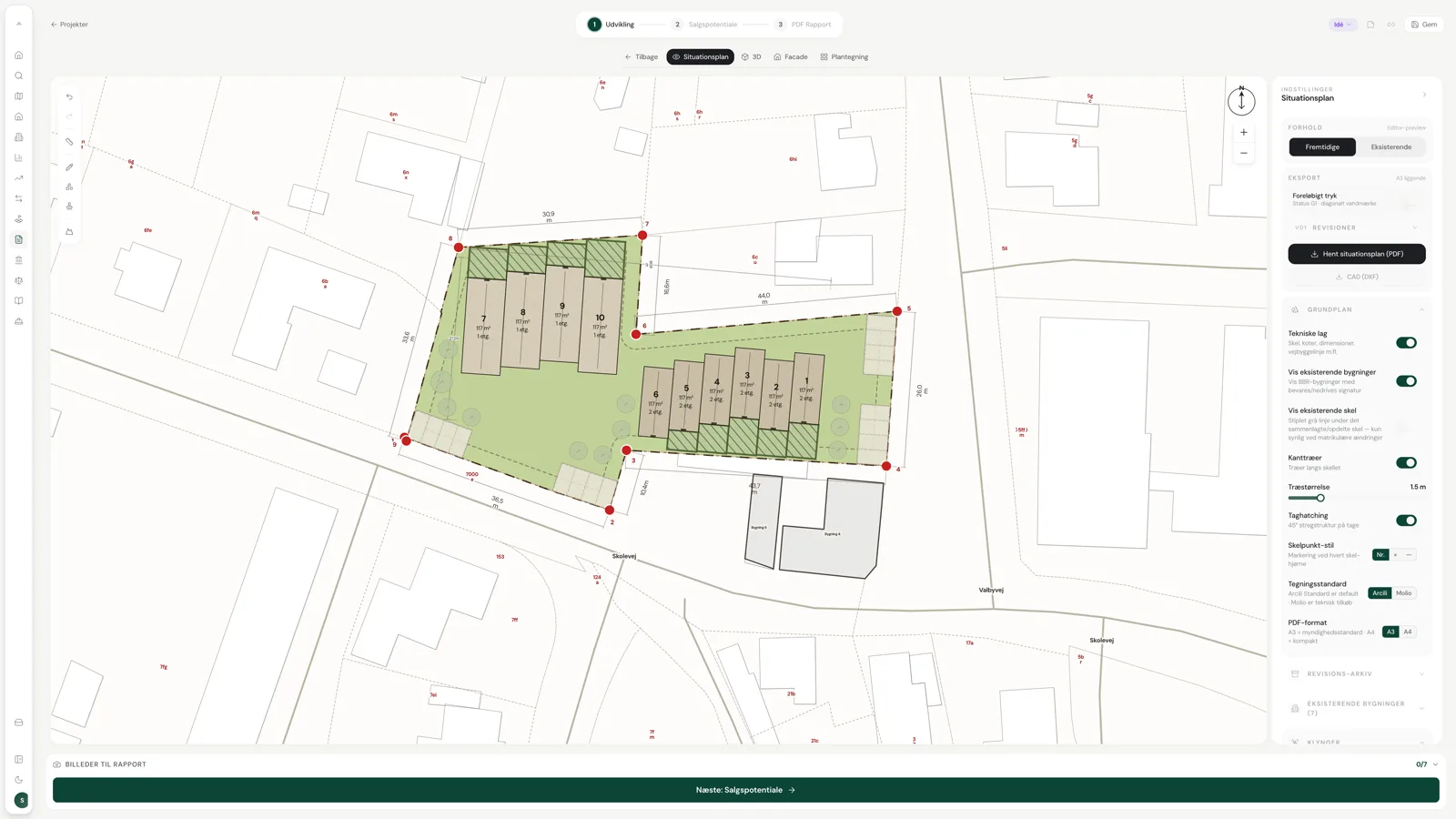
From plot to project brief in 15 minutes.
The wizard pulls local plan, municipal framework and sub-area requirements, calculates the optimal number of homes and square metres, and generates site plan, 3D model, floor plans and façade drawings. Export a ZIP ready for pre-dialogue with the municipality.
The entry point
40+ data layers — one click on the plot.
Ownership, sale prices, local plan, municipal framework, sub-area requirements, land registry, contamination, flooding, traffic noise and heritage. 3D buildings, drawing tools and measurement tools directly in the map.
The algorithm
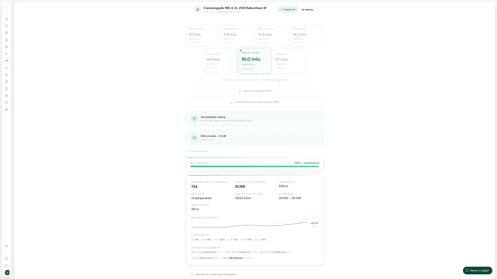
72 factors. Three confidence levels. No forecasts.
Property valuation targets individual homes; Project valuation targets new construction and commercial conversions. Both run on daily-updated transaction data and always value on the basis of what the project would yield if it stood finished today.
Search across every property and plot in Denmark. Ten detailed tabs per property: BBR, ownership chains, portfolio, transaction history, planning, land registry and surroundings.
The full CVR register with filters on industry, revenue and company type. Background checks on sellers, mapping of ownership chains and buy/sell history analysis.
Reference database of 6.3 million transactions. Search within a radius of up to 4 km, up to 24 months back. Polygon constraints and PDF export of comparables.
Four specialised AI agents: Lex (planning law), Rex (BR18 building code), Tex (VAT and real estate) and Dex (development planning). Supports file upload and image analysis.
Primary AI entry point with access to all your data on the platform. Generates analyses and presents them as interactive maps, charts and entity cards.
Arcili Docs, Sheets and Slides. Ask the assistant to write project descriptions or build slide presentations based solely on your project's actual data.
Trust, data and compliance
Large development organisations need to be able to ask about data storage, access, audit and governance before purchasing. Arcili makes those conversations concrete from the first meeting.
Hosting
Hetzner DE + Supabase EU
Data governance
EU data storage and isolated tenants
Access
SSO/SAML, OAuth and role-based access
Audit
Action log for critical workflows
Security
TLS 1.3, RLS and encryption
Support
Dedicated onboarding and enterprise dialogue
Compliance details are reviewed in the strategy meeting and tailored to the client's procurement, IT security and data processing requirements.
Procurement
A strategy meeting typically takes 30–45 minutes. We review your current workflow, data needs, integrations and where Arcili can create a stronger decision basis.
Book strategy meetingWe will clarify
Replies sent to [email protected]